Bronte Creek Active Transportation Crossing
A walking and cycling bridge over the Bronte Creek ravine — promised in the park's own management plan in 1998, budgeted for by Oakville, and still not built.
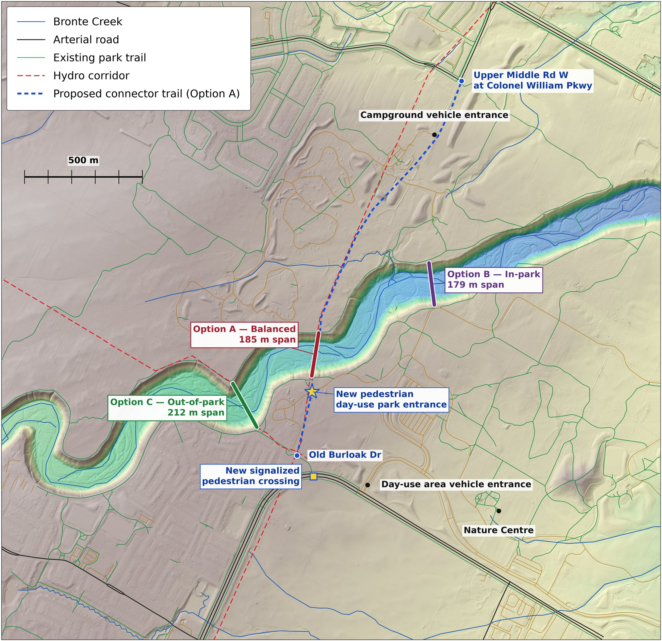
Key map — 1 m lidar hillshade (NRCan HRDEM) with OpenStreetMap overlay. Options A, B and C at their measured spans; the proposed connector trails for Option A in orange. Click to enlarge, then scroll to zoom and drag to pan.
We propose a clear-span walking and cycling bridge over the Bronte Creek ravine, joining the two halves of Bronte Creek Provincial Park and — with about 1.6 km of connecting trail — linking Old Burloak Drive in Burlington to Upper Middle Road West in Oakville, providing a needed connection between Burlington and Oakville and reducing congestion by removing unnecessary car trips from park guests. The park's approved management plan committed to this bridge in 1998. Twenty-eight years later, it still does not exist, and it should now more than ever.
A glaring gap
Two parks pretending to be one
Bronte Creek Provincial Park is one park on the map and two parks in practice.
The day-use side has the trails, the nature centre, the children’s farm, the pools and playgrounds. The campground side has the campsites, and a big quiet block of field and forest running north toward Dundas. Between them is a ravine about 200 m wide and 34 m deep, and there is absolutely no way across it.
A family camped on the north side who fancy an afternoon at the nature centre or Spruce Lane farm have to pack up the car, drive out of the park altogether, go the long way around by Dundas Street or the QEW, and come back in through the other entrance. We measured it on the road network: 6.5 km, to cross a gap of a few hundred metres. If they didn’t bring a car, they simply don’t go.
That is the small version of the problem. The large version is that the same two hundred metres also separates two municipalities and some forty-three thousand people.
The actual gap at Upper Middle Road
Bronte Creek is crossed, north to south, by Highway 407, Dundas Street, the QEW, Wyecroft Road, the Metrolinx rail bridge, Rebecca Street and Lakeshore Road.
Only 4 of these are potentially feasible for someone taking active transport, and of those, only 2 actually exist today. Lakeshore and Rebecca are both viable, but are multiple kilometres to the south, a very significant detour. Wyecroft is due to open in fall 2026 with multi-use pathways and on-road bike lanes,1 but it too is several kilometres below Upper Middle. Dundas is the closest thing to good news: its Bronte Creek crossing is already built and open, carrying a 3.0 m sidewalk with a buffered bike lane each way, and multi-use paths on both approaches. But it currently delivers you to a road that is still being rebuilt — the stretch east from Tremaine Road, past Colonel William Parkway, to Bronte Road is Halton’s Contract 2, due to complete in 2027.2 When it does, Dundas will be a genuine cycling route. It will also still be about two kilometres north of Upper Middle Road, and it does nothing at all about a provincial park split in half. None of these truly close the 4 km gap where it needs to be closed — at Upper Middle Road, the longest gap in the sequence, the one nearest to where people actually live, and the one inside Bronte Creek Provincial Park itself.
So this bridge is not just a Park “nice to have”, as the report originally suggested. It closes a major gap in the actual active transportation network between Burlington and Oakville.
Everybody already said yes
This is the part that truly surprised us during research for this proposal. We expected to find rejections of similar plans in the past; there is local community folklore of a once-planned Upper Middle Road crossing that never materialized. But that’s not what we found.
Ontario Parks committed to this bridge in 1998, in the approved management plan, in these words:
“A pedestrian bridge over Bronte Creek will be provided as a physical linkage between both sectors of the park… The size of the Nature Reserve Zone will be adjusted to the minimum extent required once the optimal location for the bridge is determined.”3
The plan lists the valley crossing first among the park’s outstanding future requirements, and the public had asked for it unprompted: of the 57 written responses to the 1997 consultation, thirty percent volunteered support for a foot bridge — more than backed the camping the plan was actually proposing. The plan even imagines the park “linked by bicycle, hiking and public transit routes to surrounding communities.”3 But the optimal location was never determined, the zone was never adjusted, and the bridge was never built.
What makes that thirty percent striking is what did not exist yet. In 1997 the park had no campground at all. The north side of the creek was open space the plan itself describes as unstaffed, with no programs or services; camping was still only a proposal in the very document those people were responding to, and the campground did not open until the 2002 season — five seasons later.4 These were not campers asking for a shortcut to the pool. They were residents asking for a way across a ravine to reach a half of their park they could otherwise only drive to.
Oakville budgeted for it. The Town’s Active Transportation Master Plan (November 2017) lists, among grade-separated pedestrian crossings then funded through its development charges by-law, one “in Bronte Creek Provincial Park (extension of Upper Middle Road at Bronte Creek)” — and the funding table for those crossings carries a column for Ontario Parks.5 Someone had already worked out who might share the bill. It was not a vague aspiration, either. Oakville’s approved capital plan carried it as project 53342404, “Bronte Creek Pedestrian Crossing”, described by the Town as:
“New construction of a signature pedestrian grade separated bridge through Bronte Creek Provincial Park which will extend and connect Upper Middle Road from Oakville to Burlington for the exclusive use of active transportation modes of travel only.”6
Scheduled 2024–2028, at $12.51M, of which $11.26M was to come from development charges.6 The Town’s 2022 development charges background study carries it too, as schedule project 14 at $12.33M (2022$).7
And then it disappeared. The project appears in Oakville’s 2023–2032 capital plan and again, rescheduled to 2026–2031, in the 2024–2033 plan. It is absent from the 2025–2034 and 2026–2035 plans, under that name or any other we could find.6 The Town’s 2025 Transportation Master Plan, which formally replaced the 2017 active transportation plan, does not carry it either.8 No development charges have ever been drawn against it.9
Burlington approved a town’s worth of new neighbours beside it. Official Plan Amendment No. 4 — Bronte Creek Meadows — was adopted by by-law in May 2025: roughly 16,000 residents in 9,000 homes on 132 hectares immediately south-west of the park, across Burloak Drive. It refers to the park repeatedly as a neighbour to connect to. It says nothing whatsoever about crossing the creek.11
So the Province, through Ontario Parks, promised it; Oakville costed it, scheduled it, and then let it fall off the books; and Burlington is building thousands of homes next to it. Three files, three organizations, one gap — and no sign that anyone has ever put them side by side.
And then thirty thousand people moved in
In fairness to everyone involved, a footbridge between two halves of a quiet rural park was, in 1998, a reasonable thing to defer. The area surrounding the park was rural farmland, and the approach roads were two-lane rural roads without sidewalks or medians. At that time, there was little active transportation traffic in this area. But the landscape around this crossing has literally changed in the last 30 years in a major way, and the plan itself saw what was coming. It called the park “an oasis in a developing urban landscape,” noted that “development continues to expand along all of its boundaries,” and predicted that “in less than twenty years, the park will be surrounded by the expansion of neighboring communities.”3
That is precisely what happened.
| Residents | Homes | Built since 2001 | |
|---|---|---|---|
| The Orchard, Burlington | ~13,700 | ~4,600 | 73 % |
| Bronte Creek, Oakville | ~13,700 | ~4,400 | 95 % |
| Bronte Creek Meadows (approved), Burlington | ~16,000 | ~9,000 | — |
Neither existing community was there in anything like its present form when that plan was signed. Almost all of the Oakville side has gone up since 2001, and more than a quarter of it since 2011 — much of that the townhouses and low-rise apartments now lining Bronte Road. Today 16,484 people live within two kilometres of where this bridge would go, and Burlington has approved sixteen thousand more.12
A bridge here has become more important than it ever was, not just for the park, but for the community that surrounds it, all thirty thousand people.
The trips people would actually take
As the founder of Burlington for Active Transport, I live in Burlington and I ride a bike frequently, and I would use this bridge very often. Getting to Oakville under my own power today means travelling over 8 km out of my way to cross at Rebecca Street. While Wyecroft is nearly done and Dundas Street is under construction, these are not yet ready, and even then, would still be significant detours from Upper Middle Road. With a bridge here it is 15 pleasant minutes through a park instead, a meaningful improvement over a multi-km detour.
I am almost certainly not alone or unusual in that. Between the Orchard, Bronte Creek and soon Bronte Creek Meadows, there are tens of thousands of people for whom a trip across Bronte Creek could be more than a leisure pursuit. On both sides are plans for commercial space - shops, restaurants, and other amenities - as well as access to the rest of both cities’ northern halves. Every one of those trips made on foot or by bike is a trip not added to the QEW, Dundas Street, Wyecroft Road, Burloak Drive or Bronte Road, helping avoid even more congestion on the few routes between the cities. And for a household in a neighbourhood still being designed, a real car-free route to the other side is the difference between needing a second car and not needing one. That is worth actual money to actual families, every month, for as long as they live there.
What we are actually crossing
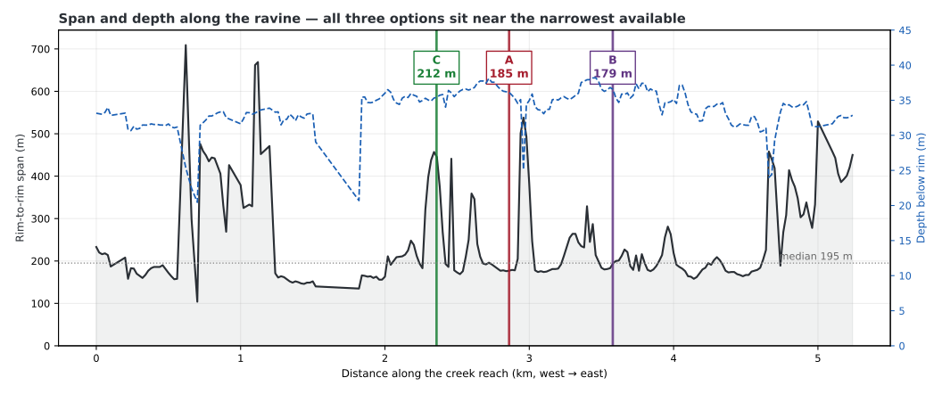
FIG. 1 — Span and depth along the ravine, from 1 m lidar. All three options sit near the narrowest crossings the park’s geometry allows.
We measured the ravine using federal 1 m lidar along the whole 5.4 km reach through the park.14 It runs between 140 m and 670 m rim to rim, with a median of 194 m, and is typically 34 m deep. It does pinch tighter in places, but only well west of anywhere that could reasonably join the two halves of the park or connect outside to Upper Middle Road on either end. Within the usable zone, the shortest crossing available is about 163 m.
That is worth saying plainly, because it closes off an obvious idea before anyone has to raise it: there is no smaller crossing hiding somewhere in this valley. A long clear span is not an indulgence here; it is the only thing that works.
Three ways across
We propose 3 potential crossings, each with different benefits and drawbacks. All three options land inside the park near the campgrounds on the north side, with differing exits on the south side.
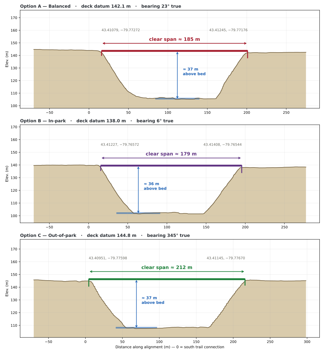
FIG. 2 — Measured ground profile along each alignment (1 m lidar), south connection to north.
| A — Balanced ⭐ | B — In-park | C — Out-of-park | |
|---|---|---|---|
| Clear span | ≈ 185 m | ≈ 179 m | ≈ 212 m |
| Height above bed | ≈ 37.1 m | ≈ 36.5 m | ≈ 37.4 m |
| Deck grade | 0.93 % | 0.84 % | 0.33 % |
| Onward connection — Burlington side | ~50 m | 570–840 m | ~13 m |
| Onward connection — Oakville side, to Upper Middle Rd W | ~1,195 m | ~755 m | ~1,565 m |
| South abutment | 43.41079, −79.77272 | 43.41227, −79.76572 | 43.40951, −79.77598 |
| North abutment | 43.41245, −79.77176 | 43.41408, −79.76544 | 43.41145, −79.77670 |
The spans differ by a maximum of 33 m and the heights by less than a metre. Structurally there is very little difference between them. What separates them is where each one lands, and how far it then has to travel to reach the exits of the route.
- Option A — balanced. The south end sits about 50 m from the end of the park’s service road off Old Burloak Drive, on ground that is already disturbed and already reachable — a service road, a hydro crossing of the ravine, and the stub end of Old Burloak Drive itself. On the north side the Hydro One right-of-way runs directly toward Upper Middle Road West, with the proposed pathway detouring to the south-east around the campground entrance plaza before paralleling the entrance stub of Upper Middle Road West, ending at the intersection of Upper Middle and Colonel William Parkway.
- Option B — in-park. The shortest span, and the closest match to the internal linkage the 1998 plan described, landing straight into the day-use trail network. It is also the closest to Upper Middle Road West as the crow flies, but its south end is 570–840 m from any onward connection through the park itself, complicating its use as a public amenity, and its north approach would have to cross open parkland rather than follow an existing corridor.
- Option C — out-of-park. Lands about 13 m from the Bronte Creek Trail — the tightest connection to the Burlington municipal network. It is also the longest span by roughly 30 m, and its Oakville-side approach is the longest of the three. Its south landing connects to City of Burlington trail lands, which makes it a partnership rather than a purely provincial project.
We recommend Option A, for several reasons. With roughly 329 m of new path on the south side and 1,243 m on the north, it is the most direct route, tracing a path that any logical connection of Upper Middle Road would take. It has the clearest connectivity with the park while not actively encroaching on its facilities, on both sides. It runs alongside the existing Hydro One right-of-way, area already disturbed by this crossing. On the way it passes through an existing junction of a park trail and a park service road, which we propose become a new pedestrian day-use park entrance (starred on the map): a walking and cycling entrance, with no new road, parking, or extra traffic, and no new ground opened up, while replacing the current single-track dirt pedestrian entrance to the west officially and increasing capacity significantly, a win for park access for non-drivers.
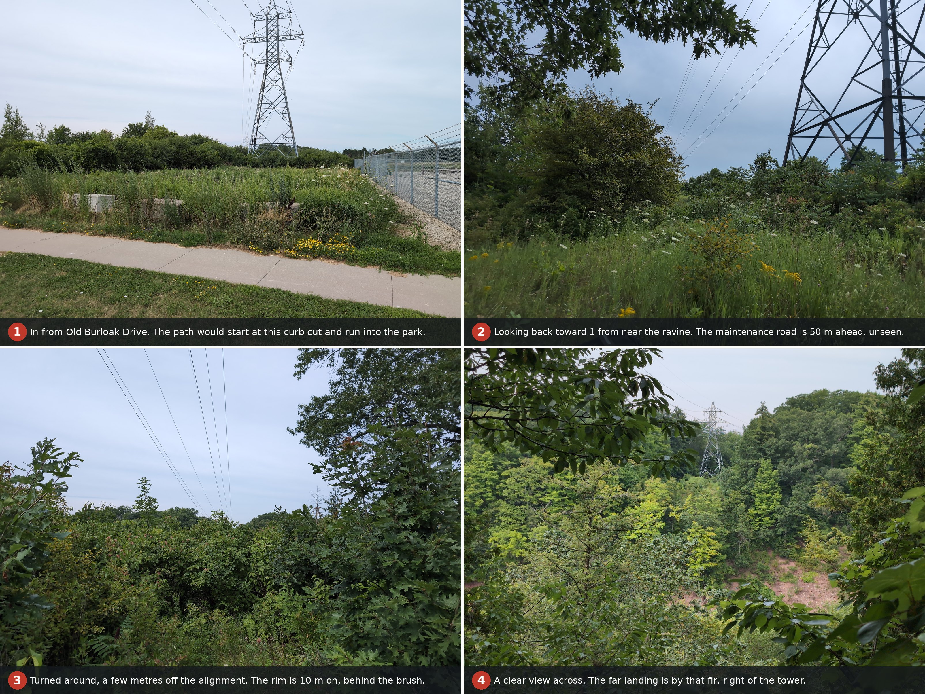
FIG. 3 — The Burlington-side approach for Option A, walked 1 August 2026. 1 the Old Burloak Drive end, beside Enbridge’s Bronte Junction: the curb cut is already there, and the concrete blocks mark the existing access corridor to the tower · 2 from the current single-track entrance path, looking back the way we came, past the ravine’s anchor tower — the maintenance road and the proposed pedestrian entrance are about 50 m ahead and completely hidden by summer growth · 3 the same spot, turned 180° toward the crossing — we are standing 3–5 m off the alignment here, where the single-track path is clearest; the rim is roughly 10 m further on, and we would expect the south landing about where the taller tree overhangs at right · 4 ten metres further west, a clear view across — the north landing would sit near the tall fir just right of the tower, on the campground side in Oakville.
Building it
A 4.0 m deck — our standard for a two-way active-transportation route, wide enough for people walking and riding to pass one another comfortably.
A span of 179–212 m at 36–37 m above the creek puts this in suspension, cable-stayed or stress-ribbon territory. A pier in the channel should be assumed unacceptable — this is a regulated watercourse inside a provincial park whose governing statute puts ecological integrity first16 — so a clear span is a requirement rather than a preference. As we are not structural engineers, we cannot confirm exactly which bridge style would be the most appropriate, but all options would serve the goal well, as well as provide excellent sightseeing and observation points of the creek and ravine below.
The terrain does us one large favour. Because every option joins two existing trails at almost the same elevation, all three decks run essentially flat: between 0.33 % and 0.93 % end to end. No switchbacks, no rest landings, no earthworks worth the name. For a crossing 37 m above a ravine floor, that is unusually kind ground.
Additional amenities
We would propose three additional amenities to improve this route even further:
-
A full signalized pedestrian crossing at Old Burloak Road and Burloak Road. Currently, the only viable Pedestrian crossing approaching this area is at Sutton Drive, nearly 1 km back from the proposed start of the path, and the existing multi-use facility runs on the south side of Upper Middle Road, opposite Old Burloak Road. As part of this plan, a proper signalized pedestrian crossing would be necessary at this intersection in order to permit pedestrians and cyclists approaching from along Upper Middle Road to reach it safely, especially as traffic density in the area increases. The upcoming Bronte Creek Meadows development may include other crossings in the area as it is built, but this is an easy win now even without the bridge plan, to facilitate access to the Bronte Creek Trail and existing single-track pedestrian/cycling entrance off of it.
-
Lighting and wayfinding will be important for this crossing; unlike the park which closes at dusk daily, this connection would also be a community amenity and require 24/7 access. We would not recommend extensive pole lighting as this would be needlessly disruptive to wildlife and the atmosphere of the creek, but a system of small wayfinding LED lights along the edge and centre of the path, spaced every metre or so and embedded in the pavement to prevent hazards to wheels, would provide sufficient illumination for safe crossing of the bridge at night. In addition, lightly-illuminated wayfinding signs at both ends, and at any connections into the park, would help ensure users can find where they’re going without getting lost.
-
Winter maintenance would be important to prevent this from only being a warm-season amenity. With the proposed form of the crossing above, sidewalk-sized snow removal equipment would be viable to ensure the bridge and pathways remain clear even in winter.
Cost, and who pays
We could find no Ontario precedent for a public crossing like this: no municipal or provincial active-transportation bridge in the province appears to carry a clear span in the 150–250 m range. The nearest useful comparable is out west, and it is a good one.
The Columbia River Skywalk in Trail, British Columbia opened in December 2016 — a 225 m suspension span with a 3.66 m walkway, rated to carry an emergency vehicle with a trailer, built for about $12.5M in contract value and $15.5M all in, and erected with a custom highline crane so that nothing had to be staged on the valley floor. It carries the city’s sewer and water mains, and that servicing component paid for 40 % of it.19
On comparable structures escalated to 2026 dollars, a 185 m span at 4.0 m wide comes out at roughly $30 million — which we would quote as a $25–45 million range at concept level (Class D, ±30 %). That is a real number. It is also not a number the Province would be carrying alone.
There are also existing plans to refurbish the pool and other facilities at Bronte Creek20; this project can be folded in under one general budget for the 2027-2032 5-year timeframe in order to provide both amenities at once.
| Source | Role |
|---|---|
| Town of Oakville | The Town costed this crossing at $12.51M with $11.26M development-charge funded and scheduled it twice, but it has not appeared in a capital plan since 2024–2033 and no charges have been drawn. Restoring it through the development charges study now under review is the first funding step, not a sum that can be assumed.6 |
| City of Burlington | “Active transportation crossing structures” are DC-eligible at 0 % benefit-to-existing within a new development area. The City has funded comparable crossings at $26.1M and $18.8M21 |
| Federal | The Build Communities Strong Fund names both active-transportation networks and parks, and its housing-enabling framing fits Bronte Creek Meadows squarely22 |
| Province | Ontario Parks capital. The Provincial Parks and Conservation Reserves Act expressly allows gifts, a retained-revenue account and partnership agreements for facility development16 |
| Utility | If the crossing carries services, the Skywalk precedent is 40 % |
Escalation uses Statistics Canada’s Toronto non-residential building construction price index as a proxy, the infrastructure and highway indexes being inactive.23 Figures are total project cost, derived from comparable structures rather than from quantities.
Approvals
Ontario replaced the Class Environmental Assessment for provincial parks in 2023 with a Project Evaluation Policy, under which a new non-motorized bridge is a minor project requiring no further evaluation where it is identified in the management plan. This one is.24
We offer that as a well-supported reading rather than a settled one. The policy’s structure-size thresholds have not, as far as we can tell, been tested against a span this large, and the ravine is Nature Reserve zone and a provincially significant Area of Natural and Scientific Interest with a 40 m crest buffer.3 If Ontario Parks judged a fuller evaluation warranted, we would support that rather than argue it.
The 1998 plan also describes a pedestrian bridge for internal use, and says it “will not provide for access from outside the park” — while elsewhere imagining links to surrounding communities. The plan is not consistent with itself here. Either way, connecting outward and carrying a service vehicle both point to a management plan amendment, which brings its own public consultation and can run alongside the project evaluation rather than after it. We think that consultation is winnable. The 1997 one was, and there are thirty thousand more people within reach of it now.
Beyond the Province the partners are Conservation Halton (valley and stream corridor permit — a slope stability assessment will govern how far back the abutments sit), the City of Burlington and Town of Oakville for the trail connections and development charges, Halton Region, and Hydro One / Infrastructure Ontario for the corridor arrangement.
What could go wrong
| Risk | Where it stands |
|---|---|
| Bank and slope stability at the abutments | The biggest unknown by a distance. No geotechnical data is available to us; Conservation Halton will require an assessment, and its outcome pushes the abutments back and lengthens the span. First job in Phase 0. |
| The span grows | Likely, for the reason above. Our figures are minimum spans measured bank to bank; carry contingency. |
| Oakville’s funding is no longer in the capital plan | The project is documented and was twice scheduled, but has not appeared since the 2024–2033 plan and no charges have been drawn. The mechanism has to be restored through the current development charges review, not assumed. |
| Nature Reserve zoning and ANSI status | The 1998 plan anticipated adjusting the zone boundary for the bridge. That adjustment, and the 40 m crest buffer, must be worked through at design. |
| Management plan amendment | Needed for the outward connection and vehicle loading. Scope it narrowly — a broad amendment risks triggering a full plan review. |
| Federal funding eligibility | Provinces are eligible applicants, but the Active Transportation Fund intake is closed and we found no precedent of federal AT money reaching a provincial park asset.25 |
| Cost | Concept-level, ±30 %, from comparables rather than quantities. |
| Personal security | CPTED (Crime Prevention Through Environmental Design) — lighting, clear sightlines the full length, defined hours if needed. |
What we are asking for
Nobody needs persuading that this bridge should exist. Ontario Parks wrote it down in 1998, Oakville costed it at $12.51M and scheduled it twice, and Burlington is approving nine thousand homes beside it. What has never happened is the three of them being in the same room — and in the meantime the one funded commitment among them has quietly lapsed.
So we are not asking anyone to commit $30 million today. We are asking for something a great deal cheaper:
- Convene Ontario Parks, the Town of Oakville and the City of Burlington. One meeting establishes whether the mandate and the money already exist between them.
- Put the crossing back into Oakville’s development charges study. The Town costed this bridge at $12.51M and scheduled it twice before it left the capital plan. The background study now being prepared, ahead of a by-law the Town expects at Council in 2027, is the place to restore it.
- Halton Region and/or the City of Burlington implement the suggested pedestrian crossing at Old Burloak Road. Even if the bridge never proceeds, this is a viable amenity in-and-of itself.
- Fund Phase 0: geotechnical and slope stability work, survey, structure selection and a Class C estimate. It is the inexpensive gate to everything else, and it is itself grant-eligible.
- Adopt Option A as the working alignment, with B and C kept as alternatives, so the bridge and its connections are designed as one thing.
- Start the management plan amendment alongside, rather than afterwards.
Twenty-eight years is a long time for a good idea to sit in a filing cabinet. The park needs this bridge, the trail networks on both sides need it, and forty-three thousand people either side of this ravine would use it. Let’s get it built.
Burlington for Active Transport Coalition · burlingtonactivetransport.ca
Basis & disclaimer. Concept-level (Class D) feasibility proposal for discussion with the Province and partner agencies. Terrain measurements derive from NRCan High Resolution Digital Elevation Model 1 m lidar (bare earth, CGVD2013) and OpenStreetMap, without survey, geotechnical or structural input; spans are measured bank-to-bank at the deck datum and are minimum values. Population and dwelling figures are computed from Statistics Canada 2021 Census dissemination-area data. Costs are order-of-magnitude 2026 CAD derived from comparable structures, not a quantity estimate. Structure type, towers, anchorages, deck materials and dynamic response are not developed and require a structural engineer. Statements about the plans and commitments of Ontario Parks, the Town of Oakville, the City of Burlington and Halton Region are drawn from their published documents; where our reading is an inference rather than a stated fact, we have said so. Full measurements, sources and method available on request. Not for construction.
Sources
-
Halton Region, Wyecroft Road Extension and Bridge Project. Halton’s project page gives completion as “Fall 2026” and describes multi-use pathways and new on-road bike lanes; no month is published, and archived captures show the date narrowing from “2026” rather than slipping. https://www.halton.ca/for-residents/infrastructure-and-growth/road-water-wastewater-construction/wyecroft-road-extension-and-bridge-project ↩︎
-
Halton Region, Dundas Street (Regional Road 5) widening. The Bronte Creek crossing sits within Contract 1 (Appleby Line to Tremaine Road, PR-2672B); Halton’s December 2025 notice records that the widening is complete and the multi-use pathways on both sides are open between Appleby Line and Tremaine Road. The facility cross-section — 3.0 m sidewalk with a 1.5 m bike lane and 0.3 m buffer on the structure, and 3.0 m multi-use path plus 1.8 m buffered bike lane on the approaches — is specified in the corridor’s 2015 Environmental Study Report. The segment from west of Tremaine Road past Colonel William Parkway to Bronte Road is Contract 2 (PR-2671B), which Halton’s notice of construction gives as expected to complete in 2027. https://www.halton.ca/for-residents/roads-construction/construction-projects ↩︎
-
Bronte Creek Provincial Park Management Plan, approved 1998 (minor amendment 2003), Ontario Parks / Ministry of the Environment, Conservation and Parks. Source of the pedestrian-bridge commitment, the list of outstanding future requirements, the 1997 consultation results, the “linked by bicycle, hiking and public transit routes to surrounding communities” policy, the internal-use limitation, and the Nature Reserve zone and ANSI designations. https://www.ontario.ca/page/bronte-creek-provincial-park-management-plan ↩︎ ↩︎ ↩︎ ↩︎
-
Bronte Creek Provincial Park campground and facilities, dating. The 1998 management plan’s inventory of the park as it then stood lists no camping of any kind and describes the north sector as unstaffed, with camping appearing only among proposals for future development. Ontario Parks’ own park webpage, last modified 4 September 2001, states “Bronte Creek is currently a day use facility. A new campground on the east side of the park will be opening during the 2002 season”; by 4 March 2002 the same page advertises the campground as “New for 2002!” Those archived pages are also the source of the quotations about driving to the pool and the 6 km figure. https://web.archive.org/web/20011007044331/http://ontarioparks.com/bron-facilities.html · https://web.archive.org/web/20020803182809/http://www.ontarioparks.com/bron-facilities.html ↩︎ ↩︎
-
Town of Oakville, Active Transportation Master Plan (Final Report, November 2017). Lists grade-separated pedestrian crossings then funded through the Town’s development charges by-law, including the Bronte Creek Provincial Park crossing, with a funding table carrying an Ontario Parks column. https://www.oakville.ca/getmedia/b8d46b59-b680-4e20-836d-82160db3047c/transportation-roads-active-transportation-master-plan.pdf ↩︎
-
Town of Oakville, Approved Capital Details. Project 53342404, “Bronte Creek Pedestrian Crossing,” appears in the 2023–2032 plan scheduled 2024–2028 at $12,509,200, of which $11,258,200 is development-charge funded, and again as project 53342602 in the 2024–2033 plan, rescheduled to 2026–2031 at $12,519,400. It does not appear in the 2025–2034 or 2026–2035 plans; we searched those documents for the project under other names and descriptions and found no match. https://www.oakville.ca/town-hall/budget-finance/ ↩︎ ↩︎ ↩︎ ↩︎
-
Town of Oakville, 2022 Development Charges Background Study, project 14, “Bronte Creek Pedestrian Crossing,” 2023–2026, $12,329,000 (2022$), of which $11,096,100 is DC-recoverable. The Town’s own capital-plan description of the project (see above) confirms it is the crossing described here. https://www.oakville.ca/getmedia/53c46280-043b-4e5d-a155-4debed86eaa8/town-hall-2022-development-charges-background-study.pdf ↩︎
-
Town of Oakville, Transportation Master Plan (approved October 2025). Does not restate the Bronte Creek crossing as a current project. https://www.oakville.ca/transportation-roads/transportation-roads-studies-and-plans/transportation-master-plan/ ↩︎
-
Town of Oakville, Development Charges Annual Reports. Appendix B lists capital projects funded from development-charge reserves by project number. No row for the Bronte Creek Pedestrian Crossing appears in the reports we reviewed, indicating no charges have been drawn against it. https://www.oakville.ca/town-hall/budget-finance/ ↩︎
-
Town of Oakville, development charges review timing. A Finance staff report dated 9 June 2026 states that “the new DC By-law with updated DC rates is currently planned to go to Council in 2027” and that preliminary rates from the new background study are not yet available. As at 29 July 2026 no consultation date had been advertised: no development-charges item appeared on the Town’s meeting calendar through to mid-2027, the Development Charges Steering Committee had no meeting posted since April 2022, and no draft study, by-law or project schedule had been published. The current by-law, 2022-068, came into force on 13 July 2022; following the 2022 amendment of the Development Charges Act extending the maximum term to ten years, it would run to 2032, so the study is a discretionary update rather than a response to expiry. https://www.oakville.ca/town-hall/budget-finance/ · https://www.oakville.ca/business-development/planning-development/development-charges/ ↩︎
-
City of Burlington, Official Plan Amendment No. 4 — Bronte Creek Meadows, adopted by by-law 31-2025 on 20 May 2025. Approximately 132 ha, ~16,000 residents in ~9,000 units and ~3,600 jobs to 2051. https://burlingtonpublishing.escribemeetings.com/filestream.ashx?DocumentId=87885 ↩︎
-
Statistics Canada, 2021 Census Profile (98-401-X2021006) at the dissemination-area level, joined to the 2021 census boundary files. Population, dwelling counts and period-of-construction shares for the Orchard, the Bronte Creek community and the two-kilometre catchment are our own computation from that data. https://www12.statcan.gc.ca/census-recensement/2021/dp-pd/prof/details/download-telecharger.cfm?Lang=E · https://www12.statcan.gc.ca/census-recensement/2021/geo/sip-pis/boundary-limites/index2021-eng.cfm ↩︎
-
Town of Oakville, Trails. Descriptions of the Crosstown Trail and Bronte Creek Trail, both of which terminate at Bronte Creek Provincial Park. https://www.oakville.ca/parks-recreation-culture/parks-gardens-trails/trails/ ↩︎
-
Natural Resources Canada, High Resolution Digital Elevation Model (HRDEM) — CanElevation series, 1 m bare-earth lidar, vertical datum CGVD2013, accessed as cloud-optimized GeoTIFF. All spans, elevations, grades and depths in this proposal are measured from this dataset. Trail, road, watercourse and utility geometry is from OpenStreetMap (© OpenStreetMap contributors, ODbL). https://open.canada.ca/data/en/dataset/957782bf-847c-4644-a757-e383c0057995 · https://www.openstreetmap.org/copyright ↩︎
-
Conservation Halton, Policies and Guidelines for the Administration of the Conservation Authorities Act and O. Reg. 41/24, and Land Use Planning Policies (last amended June 2024). Valley and stream corridor policies, slope stability assessment requirements, and the preference for using already-impacted areas of a valley slope. https://www.conservationhalton.ca/wp-content/uploads/2024/07/CH-Policies-and-Guidelines-for-the-Admin-of-the-CA-Act-and-OReg-41-24-and-Land-Use-Planning-Policies-last-amended-June-21-24.pdf ↩︎
-
Provincial Parks and Conservation Reserves Act, 2006, S.O. 2006, c. 12. Section 3 makes the maintenance of ecological integrity the first priority in park management; sections 25, 27 and 35 provide for gifts, a retained-revenue account and partnership agreements for facility development. https://www.ontario.ca/laws/statute/06p12 ↩︎ ↩︎
-
London Millennium Footbridge — synchronous lateral excitation on opening in 2000, and the damper retrofit that followed. https://news.cornell.edu/stories/2005/11/explaining-why-millennium-bridge-wobbled · https://www.designworldonline.com/dampers-show-flexibility-in-retrofit-of-londons-millennium-bridge/ ↩︎
-
CSA S6, Canadian Highway Bridge Design Code, clause 3.8.11 — a maintenance-vehicle load is required on pedestrian bridge decks with a clear width greater than 3 m where vehicular access is not physically prevented. https://www.csagroup.org/store/product/CSA%20S6:19/ ↩︎
-
Columbia River Skywalk, Trail, British Columbia — 225 m tower-to-tower suspension span, 3.66 m FRP deck, rated for an emergency vehicle with trailer, opened December 2016; carries the City’s sewer and water mains, which funded roughly 40 % of the project. https://www.grahambuilds.com/columbia-river-skywalk/ · https://www.creativecompositesgroup.com/case-studies/columbia-river-skywalk · https://canada.constructconnect.com/joc/news/infrastructure/2017/10/pipes-and-pedestrians-trail-bc-bridge-solves-two-challenges-1028291w ↩︎
-
Closure of 1.8-acre provincial park outdoor pool in Oakville entering 7th year, “The ministry has completed design work to renew the facilities and is currently evaluating procurement options to support the construction,” said Davidson. https://www.insidehalton.com/news/oakville-provincial-park-pool-closed/article_4221c2e4-8823-52e7-9cec-72dc29561693.html ↩︎
-
City of Burlington, 2024 Development Charges Background Study. Defines active transportation to include “active transportation crossing structures,” with 0 % benefit-to-existing where constructed within an area of new development, and includes comparable active-transportation grade separations at $26.1M and $18.8M. https://www.burlington.ca/en/planning-and-development/resources/Development-Charges/2024-Development-Charges-Background-Study.pdf ↩︎
-
Build Communities Strong Fund, Housing, Infrastructure and Communities Canada. Names active-transportation networks and parks and recreational facilities among eligible categories. https://housing-infrastructure.canada.ca/bcsf-fbcf/index-eng.html ↩︎
-
Statistics Canada, Building Construction Price Index (table 18-10-0289-01), Toronto non-residential series, used as an escalation proxy because the infrastructure and highway construction price indexes are inactive. https://www150.statcan.gc.ca/t1/tbl1/en/tv.action?pid=1810028901 ↩︎
-
Project Evaluation Policy for Provincial Parks and Conservation Reserves (Ontario, September 2023), which replaced the former Class Environmental Assessment. Appendix 1 lists a new non-motorized bridge as a minor project requiring no further evaluation where it is in a development or access zone, or identified in the management plan. https://ero.ontario.ca/public/2023-09/Final-PEP-PPCRA_2023_09_11%20%281%29_0.pdf · https://ero.ontario.ca/notice/019-7356 ↩︎
-
Active Transportation Fund, under the Canada Public Transit Fund, Housing, Infrastructure and Communities Canada. Provincial and territorial governments are eligible recipients and footbridges are eligible works; the intake was closed at the time of writing. https://housing-infrastructure.canada.ca/trans/index-eng.html · https://housing-infrastructure.canada.ca/trans/applicant-guide-demandeur-eng.html ↩︎