Palmer–Fairview Active Transportation Corridor
A grade-separated walking & cycling link between North and South Burlington — from the Palmer Trail at Mainway to Fairview Street.
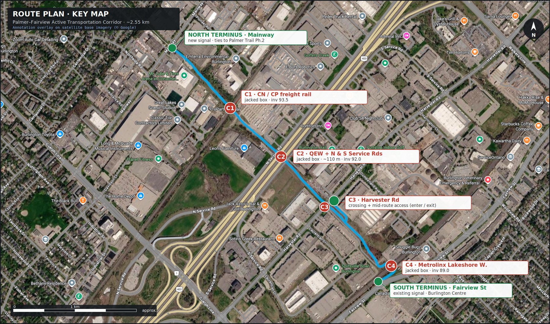
Route key map — annotation overlay on satellite base imagery (© Google). Crossings C1–C4; North, mid-route (Harvester) and South termini. Crossing locations approximate.
The proposal
A link between the two halves of Burlington
We propose a continuous, fully grade-separated walking and cycling corridor connecting Burlington north of the QEW to the Fairview Street / Burlington Centre district to the south — running its full length inside the existing Hydro One corridor, beneath the freight railway, the QEW and its service roads, Harvester Road, and the Metrolinx rail line, with no level crossing of any road or railway.
Why it matters
Burlington is a single city split into two halves. The band of industrial land running through its centre, containing two rail corridors and the QEW, acts as a near-continuous wall across the city. In a car, it is invisible; but for anyone on foot or on a bike, crossing it today means funnelling onto one of Burlington’s four major north–south arterials — Guelph Line, Brant Street, Walkers Line and Appleby Line — high-volume, car-dominated roads where active travel is unsafe and unpleasant. There is no low-stress, alternative method to cross this divide with active transportation, and this harms the ability of any other active-transportation plan in the city to succeed.
This corridor is the missing link: a single continuous, car-free spine between the city’s two halves. The benefits compound across the community.
- For residents — a safe, direct way to walk or cycle between north and south Burlington for work, school, shopping and recreation, without a car and without braving an arterial.
- For the community — it reconnects neighbourhoods, transit, employment lands and the Burlington Centre district that the QEW and rail lines have long kept apart.
- For the city — it pulls active-transportation trips off Guelph Line, Brant, Walkers and Appleby, advances Burlington’s active-transportation and climate objectives, and does it on land already in public hands.
The route
The corridor begins at the south end of the Palmer Trail at Mainway — a route the City has already extended to that point — and runs ~2.55 km south-east through the Hydro One corridor to the existing signal at Fairview Street (shown on the map above). Four barriers are crossed, each beneath the infrastructure above (C1–C4), and three doors let people on and off: Mainway in the north, a mid-route connection at Harvester Road, and Fairview in the south.
Every element uses proven methods — precast box culverts, standard multi-use path design, a Hydro One secondary-use licence. The cost is dominated by the four crossings, and the smartest savings come from building them in step with the QEW and Lakeshore West corridor works already on the horizon. This is fundamentally a grant-funded regional project, not a line item on the City’s tax base.
How it is built
Design concept
The trail is a 4.0 m asphalt path (5.0 m clear width through the underpasses, including shoulders) with 3.0 m vertical clearance. Between crossings it is held about 2 m below grade; at each crossing it dips to roughly 4.5 m below the rail or road to clear the structure above.

FIG. 1 — Longitudinal section, Mainway (north) to Fairview (south). Elevations approximate, pending survey.
The depth of each underpass is set not by headroom but by the structure that carries the traffic above. A precast box designed for freight (AREMA E80) loading places the path about 4.5 m below the top of rail. The trail itself needs no deep granular base — it sits on the box invert — but the load-carrying deck cannot be made thinner, which is why the dig is ~4.5 m rather than the 3 m of clear headroom.

FIG. 2 — Typical cross-sections: (A) at-grade / depressed corridor; (B) rail underpass box; (C) road underpass box.
The hard part
The four crossings
Every crossing is a grade separation — a precast box (culvert) jacked or built beneath the infrastructure above. There are no at-grade rail or road crossings. The crossings are independent structures, each separated by 500 m or more.
| ID | Crosses | Method | Invert | Notes |
|---|---|---|---|---|
| C1 | CN / CP freight rail | Jacked precast box | 93.5 | Beneath live freight track; Transport Canada + railway agreement |
| C2 | QEW + N & S Service Rds | Jacked box, ~110 m | 92.0 | The marquee structure; best built on an MTO QEW rehabilitation |
| C3 | Harvester Rd (Regional) | Box + access ramp | 91.0 | Includes the mid-route entrance/exit to Harvester |
| C4 | Metrolinx Lakeshore W. | Jacked box, ~25 m | 89.0 | Busy passenger corridor; coordinate with GO Expansion work |

FIG. 3 — C2 QEW crossing detail: plan and profile of the jacked box beneath the freeway and both service roads.
Keeping it dry
Drainage & operations
Honesty about the long-term liability matters. Each underpass is a low point with no gravity outlet at ~4.5 m depth, so the base assumption is four stormwater pump stations (twin pumps, standby power, high-level alarms). This is a permanent operating cost and a flood-risk item the City would own.
Detailed design should test every opportunity to reduce it: connecting a low point to a deep regional storm trunk for gravity drainage (which could delete a pump station), infiltration where soils allow, and online detention. A dedicated hydrogeological study is a first-phase priority, because the pump-station count is the largest single swing in lifecycle cost. The area’s high water table (the corridor is ~1.5 km from the lake) also means active dewatering during construction.
What it costs
Cost breakdown
The estimate is concept-level (Class D). The four crossings are ~55% of construction; the path surface itself is a minor item. Two scenarios bracket the range — the difference is almost entirely whether the QEW and Metrolinx boxes are standalone or coordinated with host works.

FIG. 4 — Component cost breakdown, coordinated scenario ($ millions, concept-level).
| Line | Coordinated | Standalone |
|---|---|---|
| Construction subtotal | $61M | $75M |
| Engineering, EA, design, agreements (~15%) | $9M | $11M |
| Contingency (25% / 30%) | $15M | $22M |
| Total project (concept) | ~$86M | ~$108M |
| City net cash after grant stacking | ~$22M | ~$27M |
Excludes land/easement beyond the Hydro One licence, and assumes no major contaminated-soil surprise. Refine at EA stage.
Who pays
Funding strategy
A regional active-transportation project of this scale is grant-stacked, not tax-funded — and Burlington has the precedent: the Palmer Trail itself was built with federal/provincial infrastructure money. The four crossings also open a second funding door that an ordinary trail cannot reach.

FIG. 5 — Indicative funding stack for a ~$90M project. City net cash share shown in red.
| Source | Vehicle | Role |
|---|---|---|
| Federal (primary) | Active Transportation Fund, under the Canada Public Transit Fund | Direct municipal application; up to ~60% federal share |
| Federal (second door) | Rail-safety / grade-separation funding (Transport Canada) | Crossings pitched as conflict elimination at active rail — a separate, stackable pot |
| Provincial | Joint federal–provincial program; MTO / Metrolinx in-kind | Ontario has no standalone AT grant; value comes via joint programs and host-corridor coordination |
| Regional | Halton Region cost-share | Harvester Road is a regional road — direct regional interest |
| Municipal | Canada Community-Building Fund; development charges | Local share and matching funds |
When
Accelerated delivery
With full agency alignment and an aggressive, parallel delivery model, this corridor does not need to be a decade-long project. The schedule below assumes the City makes it a priority, the studies run concurrently rather than in sequence, the four crossings are built in parallel rather than one after another, and — critically — the QEW and Metrolinx crossings are timed to works those agencies are already planning.

FIG. 6 — Accelerated delivery schedule (months). Phases run in parallel rather than in sequence.
The northern Hydro-corridor segment can open in about a year as a standalone deliverable — an immediate, visible result for residents while the crossings proceed. With the crossings delivered in parallel, substantial completion is achievable in roughly 2.5 years, and a two-year stretch target is realistic if the structures land inside the host agencies’ corridor windows.
Permissions
Approvals & partners
The corridor touches many authorities; each crossing depends on its host. None of these is a novel approval — they are well-trodden processes — but they are serial and time-consuming, which is why early engagement matters.
| Authority | Role / trigger |
|---|---|
| City of Burlington | Municipal Class EA (Schedule C); capital approval |
| Hydro One + Infrastructure Ontario | Secondary-land-use licence (linear trails are an eligible, encouraged use) |
| Transport Canada | Rail grade-separation approvals (C1, C4) |
| CN / CP | Freight crossing agreement, flagging, insurance (C1) |
| Metrolinx | Corridor crossing agreement, possession windows (C4) |
| MTO | QEW encroachment / Highway Corridor Management permit (C2) |
| Halton Region | Harvester Road permit (C3) |
| Conservation Halton | Watercourse / floodplain permit, if applicable |
What could go wrong
Risks & mitigations
| Risk | Mitigation |
|---|---|
| Rail / MTO approval timelines and conditions (highest) | Engage early; design to railway standards; align with host corridor projects |
| High water table & permanent pumping liability | Phase-0 hydrogeological study; pursue gravity drainage to deep trunks where possible |
| Contaminated soils (industrial corridor) | Early environmental site assessment; budget disposal in contingency |
| Host-schedule dependency (coordination savings) | Carry both coordinated and standalone budgets; don’t over-commit to a single window |
| Personal security in underpasses | CPTED design: lighting, open sightlines, no entrapment, cameras, minimal length |
| Cost escalation over a long horizon | Strong contingency; phase delivery; lock grants at design completion |
The ask
What we are asking the City to do
We are not asking the City to commit $90 million today. We are asking it to take the first, low-cost steps that make this corridor real and grant-ready:
- Fund Phase 0 — the Class EA, survey, geotechnical and hydrogeological studies. This is the inexpensive gate to everything else and is itself grant-eligible.
- Open early dialogue with Metrolinx, CN/CP and MTO to learn their corridor-work schedules — the calendar that determines whether the low-cost coordinated delivery is achievable.
- Build the northern Hydro-corridor segment from Mainway as a standalone early deliverable under the existing secondary-use framework.
- Adopt the corridor into the active-transportation plan so it is positioned for federal and provincial funding calls.
Burlington for Active Transport Coalition · burlingtonactivetransport.ca
Basis & disclaimer. Concept-level (Class D) feasibility proposal for discussion with the City and partner agencies. All alignments, elevations, dimensions and costs are approximate, developed without survey, geotechnical or railway-agreement input, and will change at the EA and detailed-design stages. Costs are order-of-magnitude (2026 CAD). Base imagery © Google. Not for construction.