Upper Middle Road Cycling Corridor
A continuous 3.45 km bi-directional protected cycling route across north Burlington — Guelph Line to Country Club Drive, refurbished with urgency on an aging facility both the City and the Region already count as built.
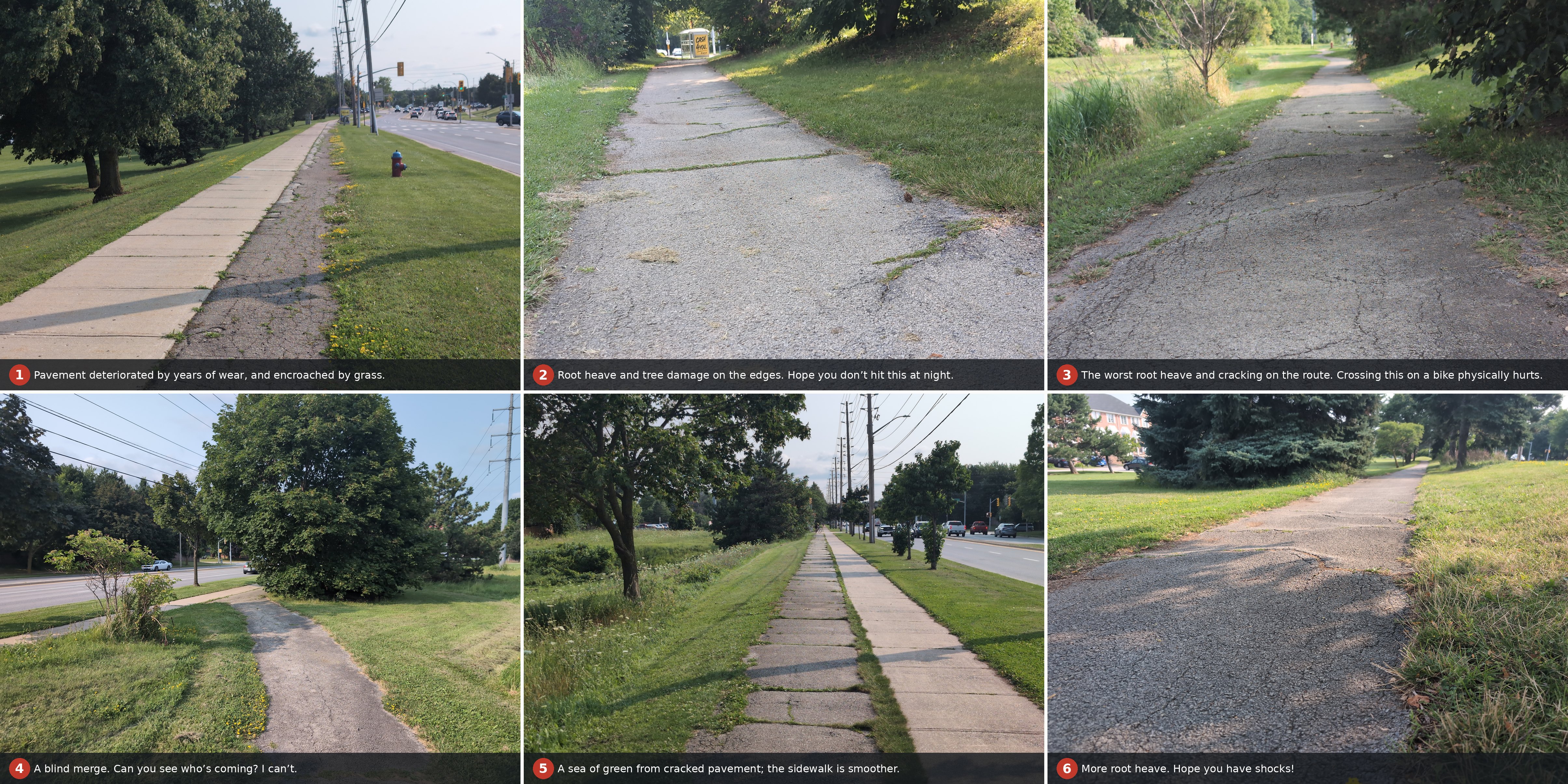
FIG. 1 — The corridor as it stands, 28 July 2026, west to east. 1 just west of Upland Drive · 2 east of Centennial Drive · 3 west of Deer Run Avenue · 4 west of Headon Road · 5 east of Headon Road · 6 east of Cleaver Avenue.
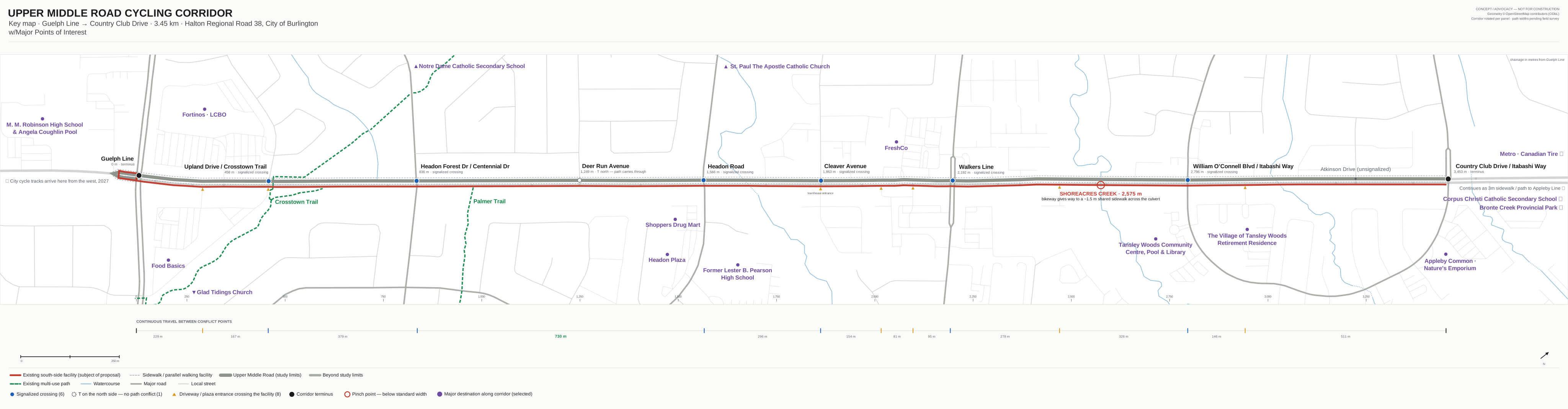
FIG. 2 — Key map, Guelph Line to Country Club Drive (3.45 km). The corridor is rotated so chainage runs west to east. Click to enlarge, then scroll to zoom and drag to pan. Alignments and chainages from OpenStreetMap (ODbL); widths pending field survey.
We propose that the City of Burlington and Halton Region rebuild the south-side path along Upper Middle Road, from Guelph Line east to Country Club Drive, as a continuous, bi-directional, protected cycling corridor — widened to standard, lit, properly signalized where it crosses traffic, and cleared in winter. The facility is already there. Burlington built it as an asphalt bikeway between 1982 and 1994, it appears on both governments' network maps, and in the forty years since, the City's own asset register records not one rehabilitation of any part of it. As a result, this amazing community amenity has been left to fall apart, impacting its usability and safety significantly. There is no better time than now — the next 2 to 3 years — for a rehabilitation and upgrade to modern standards.
A bike route that already exists on paper
Upper Middle is the only continuous east–west route across the top of Burlington. It strings together 8 of the 9 neighbourhoods in north Burlington (more than Dundas Street or Mainway).1 It runs past two high schools, multiple plazas and shops, a major community centre and retirement village, all 4 major north-south roads, and at Upland Drive it meets the Crosstown Trail — the city’s main north–south cycling spine — while the Palmer Trail joins it further east. Fix this one corridor and you have not just built 3.45 km of bike route; you have connected everything that already touches it.
Think about who that serves. A kid riding to school instead of being driven. A teenager getting to a friend’s house three neighbourhoods over without a parent in the loop. Somebody commuting to their job along Upper Middle Road, or just going to the plaza for milk, on a route where they rarely have to merge with traffic. An older resident of Tansley Woods Retirement Centre on an e-bike or a mobility scooter, for whom “a metre wide and heaved” is not an inconvenience but a hard stop.
All of those trips are being made today — by car, or not at all. Not because people up here don’t want to ride, but because the route they’d ride on has quietly fallen apart through decades of neglect.
The corridor today
Chainage runs west to east from Guelph Line. Note that all intersections are signalized today.
| Chainage | Junction | Does the path cross a road? | Notes |
|---|---|---|---|
| 0 m | Guelph Line | Yes, major intersection | Western terminus — City cycle tracks arrive here from the west in 20272 |
| 458 m | Upland Drive / Crosstown Trail | Yes, minor intersection | The Crosstown Trail also connects here |
| 836 m | Centennial Dr / Headon Forest Dr | Yes, minor intersection | The Palmer Trail connects about 50 m east from here |
| 1,249 m | Deer Run Avenue | No, minor intersection on the north side only | |
| 1,566 m | Headon Road | Yes, minor intersection | |
| 1,863 m | Cleaver Avenue | Yes, minor intersection, townhouse-complex entrance/driveway | |
| 2,192 m | Walkers Line | Yes, major intersection | |
| 2,575 m | Shoreacres Creek | N/A | Bikeway ends; a shared sidewalk carries the crossing |
| 2,796 m | Itabashi Way (West end) / William O’Connell Blvd | Yes, minor intersection | |
| 3,453 m | Itabashi Way (East end) / Country Club Drive | Yes, minor intersection | Eastern terminus, continues as sidewalk (CN underpass) and pathway past Heron Way |
A paved facility runs along the south side for 99% of the corridor — continuous on a map, and something else entirely underneath you. Root heave, alligator cracking, edge failure, and long stretches narrowed by encroaching sod to something closer to a goat track than a cycling facility.
The worst of it is the first stretch east of Guelph Line, which is also the odd one out: for roughly 350 m the path and the sidewalk swap places, the bikeway running tight against the roadway with the sidewalk outboard of it, before settling into the arrangement it keeps for the rest of the corridor. It is the first thing you meet riding east from the new City cycle tracks, and it is the piece in the poorest repair.
It was built as a bikeway, and never renewed
This is not a guess. The City of Burlington publishes its pedestrian-network asset data, and the record for this corridor is unusually clear.3
Burlington urbanized Upper Middle Road west to east as the farmland on either side became Palmer, Headon Forest, Tansley and Millcroft. The engineering drawings show the prior condition as an open ditch — and in the boulevard, drawn beside “1.5 m CONC. S/W”, a second and separate line: “1.5 m ASPH. BIKEWAY.”4
So the corridor was never meant to be a sidewalk with bikes tolerated on it. It was designed as a bike route with a sidewalk beside it — which is precisely what we are asking to have back.
The oldest 1,840 m turns forty years old this year, against a thirty-year service life it passed a decade ago. It was also narrower on the day it opened than the minimum width the Region now applies to a facility like this.5
In fairness, the path has not been entirely untouched. Here and there you will find a patch a metre or two long, almost always where something else was dug up and the surface was made good afterwards. But those are repairs to somebody else’s excavation, not renewal of the facility — and in between them the original surface has been left to fail for the better part of forty years.
Upper Middle is a road, not a stroad
Here is the good news, and it is the best practical argument for rehabilitating and expanding this particular route.
Very little crosses this path. A total of nine signalized junctions punctuate the corridor: two are its own end points, six are crossings, and one — Deer Run Avenue — is a T from the north and the path simply carries straight through. Add eight driveway and plaza entrances and that is the complete list of conflict points in 3.45 km,6 including a 730 m stretch between Centennial Drive and Headon Road where nothing crosses the facility at all. This is a boulevard, not a commercial strip, and the corridor here does not have to solve the driveway problem that defeats retrofits on ordinary arterials.
The intersections are already channelized. The 3 major crossings all have a dedicated right-turn cut lane separated from the through lanes by a raised median. Ordinarily we would criticize that geometry — channelized right turns are hostile to people walking and cycling, and we will not pretend otherwise. But those medians are already the physical separation a protected intersection is built to create. A rider can use the island between the turn lane and the through lanes as refuge and staging, exactly as pedestrians do today. This corridor does not need full protected-intersection reconstruction to become usable — which takes the largest cost and the largest political obstacle off the table.
Design concept
While the current structure has held up well, ultimately the base is the problem, and a lift of asphalt over a failed base buys perhaps five years. And build it 4.0 m wide, which is Halton’s own “enhanced” width for a boulevard facility and the width this corridor actually needs.5 The arithmetic is simple: this is a two-way route, so 4.0 m is two metres per direction — more than enough for a rider to hold their line while somebody passes them the other way, plenty of room for same-direction passing when no one is oncoming, and plenty of space for a cargo bike or a trailer or an adult riding beside a child. Halton’s 3.0 m minimum is a minimum, and its own design toolbox warns that dividing a 3.0 m trail down the middle does not leave enough width for users to stay on their side and pass one another, so we would propose the extended 4.0 m width from day one, a significant improvement over the 1.5 m current pathway.
There is definitely room for this. The right-of-way here is generous enough to carry 4.0 m across very nearly the whole corridor, with some encroachment into the Hydro One corridor running parallel to Upper Middle (as exists today), and the boulevard is already wide enough that the path and its parallel sidewalk sit apart with naturalized ground between them. Add the 0.6 m shoulder and 0.9 m clear zone to poles, hydrants, trees and guiderails that turn a nominal width into a usable one.5 Where the path meets a driveway it should hold its grade and material rather than ramping down — with only eight of them, that is affordable.
Shoreacres Creek
At 2,575 m, between Walkers Line and William O’Connell Boulevard, Upper Middle crosses Shoreacres Creek — a road bridge carrying a divided cross-section. At that crossing the cycling facility simply gives up: the path narrows to a shared sidewalk of roughly 1.5 m, separated from live traffic by a curb and nothing else. This is currently the single biggest bottleneck in the entire corridor, even without rehabilitation.
This bridge was constructed in May 1993, replacing an existing box culvert, and is thus thirty-three years old.7 We could find no record of any rehabilitation of it since. We want to be careful about how much weight that carries, though, because it is a gap in the public record rather than a finding: this stretch of Upper Middle is a Regional road, Halton publishes no structure-by-structure inventory, and the bridge does not appear in the City’s asset registers either — which is exactly what you would expect for something the Region owns. What we can say honestly is that nothing published by either government shows this structure being rehabilitated, or scheduled for it.
That matters, because thirty-three years is roughly the age at which a bridge of this vintage comes up for its first significant work, and widening the boulevard it carries is dramatically cheaper as part of a scheduled rehabilitation than as a standalone retrofit — the staging, closures and mobilization are already being paid for. The timing question is the significant one here, and it points to two ways forward depending on the answer:
Option 1 — expand the bridge during rehabilitation to carry the full corridor. If rehabilitation is coming within the 2-3 year horizon of this proposal, set the date now and require a cross-section that carries the route across it: 5.5 m of boulevard for the 1.5 m sidewalk plus the expanded 4.0 m bikeway, the same arrangement we are asking for along the rest of the corridor. If the structure genuinely cannot be made to take that, 3.0 m of bikeway is the absolute floor. This is the one place on the route where the full width may not be achievable, which is precisely why the number needs settling early in the design phase of this project.
Option 2 — build a separate bridge beside it. If rehabilitation is not forthcoming or would be excessively costly — and given that we cannot find a date, that has to be taken seriously — we would instead propose a dedicated 4.0 m metal bridge carrying the cycling route parallel to the road structure, of the same kind already in service on the south side of Dundas Street west of Appleby Line. It leaves the road bridge untouched for whenever its own rehabilitation does come due, decouples the cycling corridor from a schedule nobody has published, and closes the corridor’s worst pinch point without waiting on it. We would lean towards this option regardless, as it would allow the two discrete structures to be maintained on their own schedules going forward.
Making it a route
A rebuilt surface is a nicer place to ride, but more is needed to truly rehabilitate this as an active transportation corridor and true route.
Maintain it. Ensure the route is kept clear of obstacles. At various points, trees, bushes, and shrubs encroach on the path, providing both a direct hazard as well as obscuring views of what lies ahead. Ongoing maintenance is essential going forward, including aggressive tree and bush trimming and proper spacing given to obstacles that could interfere with the right-of-way.
Light it. There is no lighting at all on this path today. As a result, for half the year a corridor meant to serve commuting and school trips is unusable after five in the afternoon. Lighting is not a finishing touch; it is the difference between a transportation facility and a summer amenity.
Clear it in winter. Burlington clears sidewalks within 48 hours and off-road pathways — high-volume ones only — within 72.8 Three days after a storm, the trip has already been made by car or not at all. The corridor should be designated for winter maintenance at a level appropriate to a commuting route, decided with the capital commitment rather than left to an operating-budget conversation where it will quietly not happen.
Sign it. For wayfinding, add signs at both ends, at the Crosstown and Palmer Trail junctions (the latter exists already), and at every connection to the surrounding network — so it reads as a route with destinations.
Add dedicated bicycle signal heads and crossrides at all intersections, so the cycle path has clear indication separate from both car traffic and pedestrians.
Use leading intervals where possible. This allows a safer head start over turning vehicles: the cheapest collision countermeasure available at a signal, where it makes sense.
Ensure drivers are made aware. Where the route crosses traffic, install driver-focused signage at every conflict point, warning them about the bi-directional nature of the route and that the cycle traffic has priority.
Ban right-turns-on-red across the facility. Right-turns-on-red are extremely dangerous, especially to users approaching from the right — a driver is almost always looking left and advances much too far forward of their stop line, without much consideration for traffic approaching on the corridor from the right. This leads to a potential hazard that I have personally experienced my fair share of times, forcing cycle traffic to slow or completely stop and try to get the attention of the inattentive driver. Banning right-turns-on-red solves this problem completely, and the non-protected intersections such as Upland Drive, Centennial Drive, Headon Road, and both ends of Itabashi Way would be the prime targets for such a change. This does not have to be day one feature of the route, as it will almost certainly upset many local drivers; but if the signage noted above does not help, this must be considered a necessary next step to improve safety.
Refuge on the channelization islands. Formalize what the geometry already provides, ensuring space for cyclists as well as pedestrians to wait for a green signal.
Setback crossings where possible. Pull the conflict back from the turn, giving drivers a clear view of approaching riders.
None of this is merely our opinion. Halton’s own transportation plan already commits to considering protected intersections — naming corner islands, setback crossings including crossrides, refuge areas and bicycle signals — in designing facilities for people of all ages and abilities. We are asking the Region to apply its own stated approach on a corridor where it has already designated cycle tracks.9 And with only six crossings to treat, the whole intersection program is a fraction of what it would cost on a typical arterial.
Nobody’s fault, nobody’s job
The maps are the heart of it. Halton’s Active Transportation Master Plan shows a solid green existing multi-use trail along this whole stretch;10 Burlington’s Cycling Plan shows the same.11 On both, a crumbling one-metre path and a 3 m facility are drawn with the identical symbol — so to the plans of record, this corridor is already done. Nothing measures it either: roads get a Pavement Quality Index and bridges get a condition index on a fixed cycle, but the pedestrian and pathway network gets neither, only an annual trip-hazard check.12 And nothing renews it, because boulevard facilities in Burlington get rebuilt when the road is rebuilt — and this road belongs to the Region. The scale of that gap is visible in the City’s own numbers: of 247 in-boulevard asphalt pathway segments city-wide, exactly two have ever been rehabilitated.3 This corridor is not unlucky. The whole asset class has no route to renewal.
Three ordinary gaps, no bad faith anywhere, and a facility that falls through all of them.
Two governments, one corridor
Upper Middle east of Guelph Line is Halton Regional Road 38,13 but under the Municipal Act the local municipality is responsible for sidewalks on an upper-tier highway14 — and in practice Burlington maps, inspects and plows these facilities today. Where a cycling facility falls in that split isn’t settled by any agreement either government publishes, and we suspect that ambiguity is much of why this corridor has been orphaned for thirty years.
The mechanism already exists: the Municipal Act expressly permits a lower-tier municipality to build “a sidewalk or other improvement or service” on an upper-tier highway with the upper tier’s agreement. Burlington can ask; Halton can agree. And the ward councillors for this corridor also sit on Halton Regional Council — the same people can move the same motion in both chambers.
What we are asking for
Not construction dollars today — the steps that make this corridor real:
- Fund a condition assessment and functional design for the 3.45 km corridor, scoped as a bi-directional cycling facility: existing widths measured against a 4.0 m bi-directional design width, with Halton’s 3.0 m minimum as the floor,15 the six junction crossings assessed for bicycle signals and crossrides, and a costed concept. A study, not a commitment — and it produces the number every later decision needs.
- Review the Shoreacres Creek bridge to set the structure rehabilitation targets. Either set a rehabilitation date now within scope of the project, or pursue option 2 of a dedicated bridge to move forward with this proposed plan instead.
- Confirm the proposed intersection at Walkers Line and Upper Middle Road due for rehabilitation over the next 12 months. Designing this intersection properly now saves a lot of trouble later with respect to this proposal.
- Put lighting and winter maintenance in the base scope, at a service level appropriate to a commuting route.
- Settle responsibility in writing, City and Region together, using the mechanism the Municipal Act already provides.
- Correct the record and advance the timeline — the cycle tracks already designated here should move from a long-horizon line to a funded project, and the Master Plan update now funded for later this decade should show what is actually on the ground.16
- Establish a condition index for the pathway and cycling network, parallel to what roads and bridges already have. This corridor is the clearest illustration of the gap; it is not the only facility no instrument is watching.
- Set out a clear timeline for the project — this rehabilitation is sorely overdue, and expecting the community to wait another half-decade or more is simply not viable. We would urge that this project be pushed for the 2027-2029 timescale — 2 to 3 years out at a maximum for full completion.
Burlington for Active Transport Coalition · burlingtonactivetransport.ca
Basis & disclaimer. Advocacy proposal prepared from public planning, budget and standards documents, open geospatial data, and the coalition's own field observation. Corridor length, chainages and the junction inventory are derived from open data and are approximate, pending survey. Construction years, as-built widths, service life and the absence of any rehabilitation record are read directly from the City of Burlington's published Pedestrian Network asset data, and construction dates are corroborated by the City's own engineering drawings (series MU-1). "No recorded rehabilitation" means exactly that, and not "never touched": short patches — typically one to five metres, usually incidental to other excavation — are visible along the corridor, and routine patching of that kind would not generate a rehabilitation record. The recorded condition score is derived from asset age rather than from inspection — this corridor has never been condition-assessed. Present-day widths and surface condition are observational, pending a measured field survey. Nothing here constitutes an engineering assessment. Where a fact could not be confirmed — notably the allocation of maintenance responsibility for in-boulevard cycling facilities on Regional roads — we have said so rather than assumed. We welcome correction from either government and will publish it.
-
Burlington Neighbourhoods — Map of Burlington. Neighbourhood boundaries and names, used for the count of neighbourhoods in north Burlington served by this corridor. https://burlingtonneighbourhoods.com/map-of-burlington/ ↩︎
-
City of Burlington, Upper Middle Road Phase One — Minor Reconstruction and Watermain Installation (Mountain Grove Avenue to Guelph Line). City-installed sidewalks and off-road cycle tracks are scheduled from spring 2027. This work is on the City-owned portion of Upper Middle Road, west of Guelph Line, and stops at the western end of this corridor. https://www.burlington.ca/en/news/current-city-projects-and-construction/upper-middle-road-phase-one-minor-reconstruction-and-watermain-installation.aspx ↩︎
-
City of Burlington, Pedestrian Network asset data (RoadStructures MapServer layer 40; also published through the City’s open-data portal). Source of every figure here for construction year, recorded width, assigned useful life, condition score, rehabilitation year and assessment year — including the ninety records covering Upper Middle Road, their 1986/1993/1994 construction years, 1.5 m recorded width, thirty-year service life, condition score of 1 and blank rehabilitation and assessment fields; the 220 records elsewhere in Burlington that do carry a rehabilitation year; and the finding that 2 of 247 in-boulevard asphalt pathway segments city-wide record any rehabilitation. The condition score is derived from asset age, not from inspection. https://mapping.burlington.ca/arcgisweb/rest/services/COB/RoadStructures/MapServer/40?f=pjson · https://navburl-burlington.opendata.arcgis.com/datasets/Burlington::pedestrian-network ↩︎ ↩︎
-
City of Burlington, engineering drawings, series MU-1 (Upper Middle Road plan and profile). Title blocks date the sheets between March 1982 and May 1994 and show the pre-existing condition as an open ditch. Sheets along this corridor label the boulevard facilities separately as “1.5 m CONC. S/W” and “1.5 m ASPH. BIKEWAY” — elsewhere “2.0 m ASPH. BIKE-WAY” and “PROP. 2 m ASPH. BIKE-PATH”. https://opendata.burlington.ca/Locates/Records_Stormsewer/MU-1_09.TIF · https://opendata.burlington.ca/Locates/Records_Stormsewer/MU-1_14.TIF · https://opendata.burlington.ca/Locates/Records_Stormsewer/MU-1_16.TIF ↩︎
-
Halton Region, Active Transportation Master Plan, Appendix G — Active Transportation Design Toolbox (May 2015): boulevard multi-use trail minimum width 3.0 m, enhanced width 4.0 m, minimum 0.6 m shoulder and 0.9 m clear zone on both sides. The same document cautions that segregating a 3.0 m trail into halves “does not provide sufficient width for cyclists or wheelchair users to remain on their side and pass each other”. Corroborated by the Regional Right-of-Way Guidelines (Transportation Master Plan to 2031, Appendix E), requiring a “sidewalk / multi-use path at a minimum width of 3.0 metres” on both sides of a Corridor road. https://www.halton.ca/for-residents/infrastructure-and-growth/infrastructure-master-plans/active-transportation-master-plan/appendix-g-at-design-toolbox · https://www.halton.ca/For-Residents/Roads-Construction/Infrastructure-Master-Plans/Transportation-Master-Plan-to-2031-The-Road-to-C/Appendix-E-Transportation-Master-Plan-to-2031 ↩︎ ↩︎ ↩︎
-
OpenStreetMap (© OpenStreetMap contributors, ODbL), queried through the Overpass API. Corridor length, chainages, the junction inventory, the identification of north-side and south-side legs at each junction, the driveway and plaza entrance count, the Shoreacres Creek crossing location and the continuous-travel distances shown in Figure 1 are our own computation from that data. https://www.openstreetmap.org/copyright · https://overpass-api.de/ ↩︎
-
City of Burlington, engineering drawing MU-1 sheet 17 — “Upper Middle Road, 230 m E. of Walkers Line – 280 m easterly”, City of Burlington Engineering Department, Contract No. 93-1, title block dated May 1993. The profile at the creek is annotated “EXIST. 6.1m x 1.3m CULVERT TO BE REMOVED”; the plan carries a leader to the crossing reading “FOR PROP. BRIDGE SEE DWG. MCB-309-D (SHEETS 1–7)”, and dimensions the crossing as 6.60 m + 5.0 m + 6.60 m. The same sheet labels the boulevard “1.5m CONC. S/W” and “FUT. 1.5m ASPH. BIKEWAY”. May 1993 is the drawing and municipal-approval date, so construction follows in 1993–94; we have not obtained drawing set MCB-309-D, which is not in the City’s published index and would give the structure’s span, deck width and whether the bikeway was designed across it. Upper Middle Road east of Guelph Line is Halton Regional Road 38, and the structure appears in neither the City’s bridge nor its culvert asset layer, consistent with Regional ownership; Halton publishes no structure-level inventory, so no inspection record or rehabilitation history for it is publicly available. https://opendata.burlington.ca/Locates/Records_Stormsewer/MU-1_17.TIF · https://mapping.burlington.ca/arcgisweb/rest/services/COB/CulvertsStructures/MapServer/0 · https://mapping.burlington.ca/arcgisweb/rest/services/COB/RoadStructures/MapServer/1 ↩︎
-
City of Burlington, Snow Removal Plan. Sidewalks are cleared within 48 hours; off-road pathways, high-volume paths only, within 72 hours. https://www.burlington.ca/en/roads-parking-and-traffic/snow-removal-plan.aspx ↩︎
-
Halton Region, Water, Wastewater and Transportation Integrated Master Plan, Volume 5: Transportation (strategies adopted by Regional Council November 2025, report PW-35-25). The 2051 Regional Cycling Network designates cycle tracks on Upper Middle Road in Burlington — one-way from Guelph Line to Appleby Line — with sidewalks as the parallel walking facility. The plan commits to considering protected intersections, naming corner islands, setback crossings including crossrides, pedestrian refuge areas and bicycle signals, in designing active-transportation facilities for people of all ages and abilities. https://www.halton.ca/getmedia/760228fa-711b-4b70-ad1b-b079fe9f1432/pw-imp-vol-5-transportation-report-mar-2026.pdf ↩︎
-
Halton Region, Active Transportation Master Plan, Appendix H — Existing and Proposed Regional Cycling and Walking Network Maps (2014–2015). Maps 3 and 4 show a solid-green existing “Boulevard Multi-Use Trail” along Upper Middle Road for the full Guelph Line to Burloak Drive length, drawn with the same symbol regardless of actual width. https://www.halton.ca/for-residents/infrastructure-and-growth/infrastructure-master-plans/active-transportation-master-plan/appendix-h-existing-proposed-regional-cycling ↩︎
-
City of Burlington, Burlington Cycling Plan (November 2020). Map 1, the existing cycling network, shows a continuous multi-use path along Upper Middle Road east to Burloak Drive. The plan also records that when roads are resurfaced or rebuilt “only a ’like for like’ is budgeted”, and that coordination is needed to do better. https://www.burlington.ca/en/council-and-city-administration/resources/Integrated-Mobility-Plan/Burlington-Cycling-Plan-Final.pdf ↩︎
-
City of Burlington, 2025 Asset Management Plan. Roads are managed against a Pavement Quality Index and bridges against a condition index reassessed on a fixed cycle; the Pedestrian Network asset class — 817 km, $167.8M, average age 32 against a 60-year average service life — carries neither, with inspection conducted against the legislated minimum maintenance standards. https://www.burlington.ca/en/council-and-city-administration/resources/Plans-Reports-and-Studies/Asset-Management-Plan/2025-Burlington-Asset-Management-Plan.pdf ↩︎
-
Halton Region By-law 1984-1 (office consolidation), schedules of Regional roads, establishing Upper Middle Road from Guelph Line to Burloak Drive as Regional Road 38 and defining “boulevard”, “sidewalk” and “combined facility” as parts of the highway. Corroborated by the Region’s Regional Road Network map and by City of Burlington Official Plan Table 2, which marks both segments “Regional Road — Refer to the Regional Official Plan”. https://www.halton.ca/the-region/regional-council-and-committees/by-laws · https://www.burlington.ca/en/planning-and-development/resources/Official-Plan-2020/Table-2-Working-Version.pdf ↩︎
-
Municipal Act, 2001, S.O. 2001, c. 25, section 55. Subsection 55(1) makes the lower-tier municipality responsible for the construction and maintenance of sidewalks on an upper-tier highway and gives it jurisdiction over that part of the highway; subsection 55(3) permits a lower-tier municipality to construct “a sidewalk or other improvement or service” on an upper-tier highway with the upper tier’s agreement. Whether an in-boulevard cycling facility falls within “sidewalk” for these purposes is unsettled, and no agreement between the City and the Region on the point is published. https://www.ontario.ca/laws/statute/01m25 ↩︎
-
Ontario Traffic Manual, Book 18 — Cycling Facilities (June 2021). In-boulevard multi-use path widths: desirable 3.5 m, suggested minimum 3.0 m, with reduced widths permitted only over very short distances in constrained areas. Book 18 is guidance, and states that it is not intended as a basis for establishing civil liability. https://otc.org/wp-content/uploads/2025/04/OTM-Book-18-Cycling-Facilities.pdf ↩︎
-
Halton Region, 2026 Budget and Business Plan — Capital Report. Programs design funding for the Upper Middle Road widening (Appleby Line to Burloak Drive) later this decade and funds a Region-wide Active Transportation Master Plan update in the same period. No state-of-good-repair item for the Guelph Line to Country Club Drive stretch appears in the 2024, 2025 or 2026 capital reports. https://www.halton.ca/repository/2026-budget-and-business-plan-capital-report ↩︎